

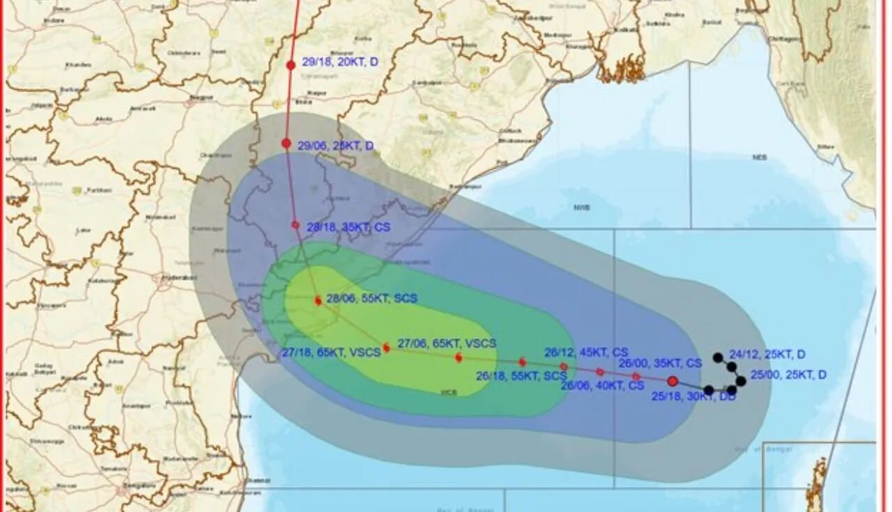
Bhubaneswar: The deep depression over the Bay of Bengal has intensified into a cyclonic storm, reportedly named Cyclone Arnab, and is moving towards the eastern coast. The system is expected to make landfall along the Andhra Pradesh coast on October 28, potentially bringing strong winds and heavy rainfall to several areas.
According to the information provided in the report, the storm could cross the coast between Visakhapatnam and Bapatla around the forenoon of October 28. Wind speeds are forecast to increase significantly as the system approaches land.
Although Andhra Pradesh is expected to experience the direct impact, parts of southern Odisha may also face heavy rainfall and strong winds as the system advances towards the coast.
Cyclone Arnab Intensifies Over the Bay of Bengal
The weather system has strengthened from a deep depression into a cyclonic storm over the east-central and adjoining southeast Bay of Bengal. It is reportedly moving towards the coast at approximately 8 kmph.
The system is expected to intensify further before approaching Andhra Pradesh. Forecasts cited in the report indicate that it could develop into a stronger cyclonic storm by Monday morning.
The storm’s intensity, movement and landfall conditions will determine the extent of its impact on coastal Andhra Pradesh and neighbouring parts of Odisha.
Andhra Pradesh Landfall Likely Between Visakhapatnam and Bapatla
The cyclonic system is expected to cross the Andhra Pradesh coast between Visakhapatnam and Bapatla on the morning of October 28.
The report places the system approximately 820 km east-southeast of Visakhapatnam, 910 km east-southeast of Kakinada, 1,010 km east of Machilipatnam and 1,080 km east of Bapatla. It was also reported to be around 450 km north-northwest of Vijayapuram.
Wind speeds at landfall have been reported in the range of 115–125 kmph, with another estimate in the supplied report suggesting speeds could reach around 140 kmph. These figures differ, and the latest official India Meteorological Department (IMD) bulletin should be consulted for the current forecast.
The approaching storm has prompted weather authorities to issue warnings for several states along and near its projected path.
IMD Issues Red Alerts Across Four States
The India Meteorological Department has reportedly issued red alerts for heavy rainfall in several districts across four states.
According to the supplied report, the warnings cover:
- Andhra Pradesh: 11 districts
- Odisha: Five districts
- Chhattisgarh: Four districts
- Telangana: Four districts
Andhra Pradesh is expected to bear the main impact because of the projected landfall. However, the system’s movement and associated rain bands could also affect neighbouring states.
Residents in warning areas should monitor official weather bulletins and follow instructions from district administrations.
Five Southern Odisha Districts May Experience Cyclone Effects
Although the system is expected to make landfall in Andhra Pradesh, southern Odisha may also experience adverse weather conditions.
Five southern districts bordering Andhra Pradesh have been identified in the report as potentially affected areas. Rainfall and strong winds are expected to begin in parts of Odisha from October 27.
The extent of the impact will depend on the storm’s intensity, its landfall location and its movement after crossing the Andhra Pradesh coast.
Authorities and residents in southern Odisha are therefore expected to remain alert as the weather system approaches the eastern coastline.
Rain and Strong Winds Expected in Odisha from October 27
The approaching cyclone has raised concerns about rainfall and wind conditions across southern Odisha.
Rain is expected to begin from October 27, with the possibility of strong winds as the system moves closer to the coast. Weather conditions after landfall will depend on how quickly the storm weakens or changes direction over land.
People living in vulnerable areas should secure loose outdoor objects, avoid unnecessary travel during severe weather and follow official instructions. Fishermen should comply with any restrictions issued by the authorities.
Cyclone’s Movement After Landfall to Determine Odisha’s Impact
The storm is expected to move inland after crossing the Andhra Pradesh coast. Its subsequent movement will be an important factor in determining how much rainfall and wind Odisha experiences.
Even if Odisha remains outside the storm’s direct landfall path, the state may still experience indirect effects from the system.
Residents should continue to follow IMD updates and district-level advisories as forecasts are revised.